Introduction

The Connecticut Department of Transportation (CTDOT) is developing a new Statewide Active Transportation Plan (ATP). The ATP will be a tool to help CTDOT fulfill their mission of “Improving lives through transportation.”  When completed, the ATP will promote safety, accessibility, and connectivity by integrating a Complete Streets and Safe System Approach to planning, designing, building, operating, and maintaining active transportation infrastructure on state roadways. 

Please watch this brief video by the Commissioner of CTDOT, Garrett Eucalitto.

Complete Streets

Consistent with the Complete Streets engineering design criteria, the Active Transportation Plan will follow a Complete Streets approach to planning, designing, building, operating, and maintaining transportation infrastructure, which enables safer access for all people, including people walking, biking, driving, and using transit, including all ages and all abilities.

The National Complete Streets Coalition provides excellent resources on Complete Streets: About the Coalition - Smart Growth America

The Safe System Approach

Consistent with the Vision Zero Council’s commitment, the Active Transportation Plan will follow the U.S. DOT’s Safe System Approach which is a holistic and comprehensive approach for making roads safer for people by building and reinforcing multiple layers of protection to both prevent crashes from happening and minimize the harm caused to those involved when crashes do occur.

Learn more about the Safe System Approach here: What Is a Safe System Approach? | US Department of Transportation

Why is Active Transportation Important?

biker and wheelchair icon

Active Transportation includes walking and biking, as well as other human-powered devices like roller skates and skateboards, assistive mobility devices and human-scaled electric mobility devices, such as e-bikes and e-scooters. Having a connected network of active transportation facilities like sidewalks, multi-use trails, and bike lanes, can help create vibrant communities by providing safe, comfortable, convenient, reliable, zero-emission, and affordable ways for people to get around.

Benefits of Active Transportation

scooter icon

Equitable Mobility

Active transportation facilities give people who cannot or do not want to drive more options for getting around independently. Providing active transportation facilities enables children, seniors, those with disabilities, and others to get where they need to go. Active transportation facilities provide all with affordable mobility options that connect them to essential destinations and public transit.

bike icon

Safety

Active transportation facilities give people walking and biking dedicated space and separation from motorized traffic. They are proven safety countermeasures promoted by the Federal Highway Administration. That means that these facilities have been studied and shown to reduce the number of crashes or crash severity. Street design including active transportation facilities can encourage people driving to travel more slowly which improves safety for all road users.

stethoscope icon

Health

Active transportation is an accessible way to incorporate physical activity into our daily lives. Providing active transportation facilities can help encourage people to walk, bike, or roll which benefits health by lowering the risk of heart disease, reducing high blood pressure, and relieving stress.

portrait icon

Quality of Life

Beautiful and well-maintained sidewalks, bike lanes, and multi-use trails are key elements of vibrant and livable communities. These facilities encourage social interaction and provide convenient, accessible mobility options for everyone.

trees icon

Environment

The transportation sector is the leading source of greenhouse gas emissions in the United States. A shift of some trips from driving to walking, biking, or other non-motorized modes reduces greenhouse gas emissions. Plus, walking and biking helps people to get closer to nature care more about our environment.

bar chart icon

Economy

Places that are easy to walk or bike around attract and retain residents, businesses, and tourism. This can boost nearby property values and economic activity. Active transportation facilities provide greater access to essential services, businesses, and employment. Plus, when people choose to walk, bike, or use transit rather than drive, they also save money which can be used for other purposes.

Activity

Complete Streets

In the last 15 years, Connecticut has taken significant steps towards improving conditions for people to walk and bike.

In 2014, CTDOT adopted a Complete Streets Policy that directs every bureau in the Department to consider the needs of all roadway users in the planning, programming, design, construction, retrofit, and maintenance of all state roads and streets.

In 2023, CTDOT expanded their Complete Streets Policy with a new Engineering Directive that requires the use of Complete Streets engineering design criteria for all departmental projects, ensuring that every project addresses biking and walking facilities and public transportation operations to create stronger intermodal transportation networks, improve safety, and improve lives.

Before

street without crosswalk

After

street with crosswalk

The concept of Complete Streets is that streets are designed and operated to enable safe use by all transportation users, regardless of whether they are driving, walking, biking, using a mobility device, or using public transit. In short, Complete Streets are streets for everyone. Complete Streets policy and design criteria helps to ensure streets are safer for people of all ages and abilities, including the most vulnerable users, and that they address the needs of different modes, and support local communities.

Complete Streets Components


                                            Safe Crossings
                                            Parking
                                            Bicycle Travel
                                            Vehicular Travel
                                            Transit Travel
                                            Transit Amenities
                                            Pedestrian Travel
                                            Public Amenities
                                            Green Areas
Click image to expand.

Although the guiding principle for Complete Streets is to create roadways that provide safer travel for all transportation users, each street has to be customized to the characteristics of the area the street serves. The image above displays the typical elements that make up a complete street. Certainly, a design for a complete street in a rural area will look quite different from one in an urban or suburban area. For example, a complete street in a rural area could involve providing wide shoulders or a separate multi-use path instead of sidewalks. The common denominator, however, is balancing safety and convenience for everyone using the road.

Activity

Active Transportation Principles

Complete Streets are built on the premise that transportation choices should be safe, convenient, reliable, affordable, and accessible. When we consider how to make our state roads more complete, we apply these five Active Transportation Principles:

checkmark shield and thumbs up

Safety: Does the network provide routes that minimize risk of injury and danger (both traffic and personal security)? 

house

Comfort: Does the network appeal to a broad range of age and ability levels and are there user amenities (e.g., places to sit, ways to be protected from weather)?

street sign

Coherence: Can users easily navigate through intersections? How connected is the network?

three-way arrow

Directness: Does the network provide direct and convenient access to destinations?

hand holding sprout

Attractiveness: Does the network incorporate nature? Is the network well-maintained, quiet, and celebrating local art and culture?

Activity

Crash Data

bike and car icon

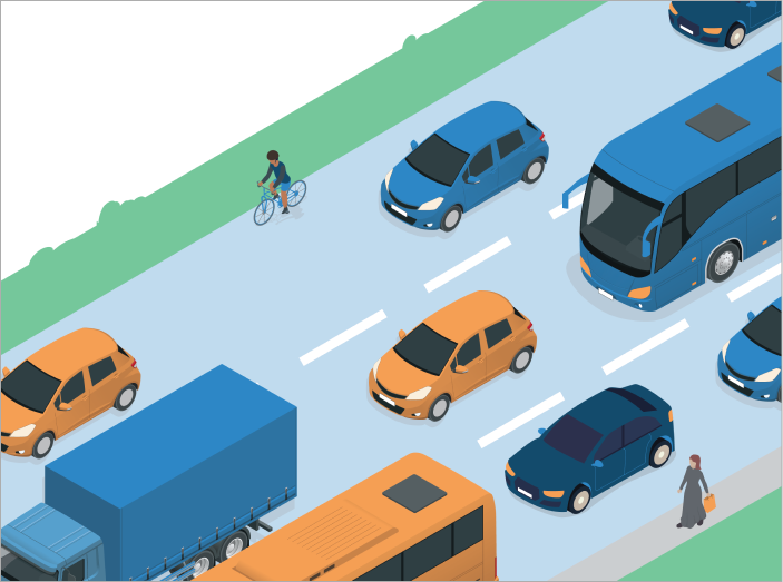
People biking, walking or using a mobility device are considered “vulnerable road users” because they are not protected by the structure and safety elements of a motorized vehicle. Because of this lack of protection, when someone walking or biking is in a crash with someone driving a vehicle, the person walking or biking is much more likely to suffer a serious or fatal injury than the driver.

Between 2019 and 2023, there were 7,089 crashes that involved at least one person biking or walking in Connecticut. Approximately 17% of those crashes resulted in fatal or serious injuries. For comparison, of all motorists-only crashes between 2019 and 2023, approximately 1% lead to a fatal or serious injury.

Statewide Pedestrian-Related Crash Data (2019 – 2023)

52 work zone-related pedestrian crashes 28 school bus-related pedestrian crashes
Crashes by Severity: 
                                                    5% - Fatal Injury
                                                    , 15% - Suspected Serious Injury
                                                    , 45% - Suspected Minor Injury
                                                    , 18% - No Apparent Injury
                                                    , 27% - Possible Injury
Crashes by Year
shoes and flower hanging from tree
Source: Watch For Me CT
Crashes by Time of Day
Route Classification for Crashes:
                                                        50% - Local
                                                        , 26% - State
                                                        , 9% - Unknown
                                                        , 3% - Interstate
                                                        , 12% - US Route

Statewide Bicycle-Related Crash Data (2019 – 2023)

2 work zone-related bicycle crashes 4 school bus-related bicycle crashes
Crashes by Severity: 
                                                    1% - Fatal Injury
                                                    , 7% - Suspected Serious Injury
                                                    , 48% - Suspected Minor Injury
                                                    , 19% - No Apparent Injury
                                                    , 25% - Possible Injury
Crashes by Year
bike memorial with flowers
Crashes by Time of Day
Route Classification for Crashes:
                                                        55% - Local
                                                        , 30% - State
                                                        , 2% - Unknown
                                                        , 1% - Interstate
                                                        , 12% - US Route

Activity

Bicycle Level of Traffic Stress

Types of Cyclists

To help plan bicycle facilities and programs, it is helpful to understand how people view bicycling. Research has suggested that people generally fall into four different categories:

biker with helment icon

Strong and Fearless

People willing to bike with limited or no dedicated bike facilities.

biker with backback and helmet icon

Enthused and Confident

People willing to bike if some dedicated bike facilities are in place.

biker with helmet and headlight icon

Interested but Concerned:

People willing to bike if high-quality bike facilities are in place.

car icon

No Way, No How

People unwilling or unable to bike even in high-quality bike facilities are in place.

37% - No Way No How
                                                            7% - Strong & Fearless
                                                            5% - Enthused & Confident
                                                            51% - Interested but Concerned
Source: Types of Cyclists – Jennifer Dill, Ph.D. 

These four categories are directly related to the type of bikeways that they need to have in place to feel comfortable biking on or near the street. Strong and fearless people will bike even in highly trafficked areas.

Enthused and confident people will bike in some areas that seem stressful to other but prefer to use dedicated bikeways.

Over half of the population is interested in biking more, but they are concerned about something, which holds them back. One goal of the active transportation plan is to establish the type of bikeways that will make this group feel comfortable and confident enough to get out and bike around their communities.

About 37% of the population will not or cannot bike, regardless of the type of bikeway available.


Bicycle Level of Traffic Stress

Bicycle Level of Traffic Stress (BLTS) measures how comfortable or stressful it is to ride a bicycle on a particular roadway. It is calculated based on several roadway characteristics, including: 

  • number of travel lanes
  • daily traffic volumes
  • speed limit
  • presence of on street parking
  • type of bikeway

BLTS scoring is designed to correspond with the four different types of cyclist categories, with a range of BLTS 1 to BLTS 4, where 1 represents the lowest stress and 4 represents the highest stress. Essentially, as motor vehicle traffic volumes and speeds increase and the separation between a person bicycling and motor vehicle traffic decreases, the BLTS scores increase.

BLTS Score Type of Bicyclist Facility Type
cyclist with helmet
BLTS 4
“Strong and Fearless”
Challenging for most adults.
BLTS 4
cyclist with helmet and backpack
BLTS 3
“Enthused and Confident”
Suitable for many adults.
BLTS 3
cyclist with helmet and headlights
BLTS 2
“Interested but Concerned”
Suitable for most adults.
BLTS 2
cyclist with baby carrier
BLTS 1
“All Ages and Abilities”
Suitable for almost all cyclists, including children.
BLTS 1

Existing Bicycle Level of Traffic Stress

map of the draft Existing
												Conditions BLTS results.

The map on the left displays the draft Existing Conditions BLTS results. CTDOT will use the BLTS results to assess the connectivity of its bicycle network and identify where and how the connectivity can be improved.


Activity

Existing Active Transportation Network

To encourage more walking and biking, safe and protected bikeways and walkways that create a connected network are a must. Just like our roadway network, a connected active transportation network allows walking and biking to be viable transportation options.

In the last 20 years, Connecticut has seen substantial improvements in the bicycling and pedestrian environment, specifically their multi-use trail network. However, there is still a lot of work to be done to create a safe, comfortable, convenient, and reliable statewide active transportation network.

Interactive Map

No one knows your community better than you! We want to know your comments on the existing active transportation network in Connecticut and how it can be better. Use the interact map below to add your input. Or alternatively fill out this comment form.

Thank You & Next Steps

Thank you for taking the time to participate in this online meeting. Your input is vital as we continue to develop the Statewide Active Transportation Plan.

Project Schedule

This is only the first phase of our equitable outreach and engagement for the Statewide Active Transportation Plan. We will hold another series of open houses in the summer and again next winter.

In addition to open houses, the CTDOT project team will hold a series of focus groups, distribute multiple online surveys, and host a variety of pop-up events.

Existing Conditions & Needs
                                            Proposed Recommendations
                                            Active Transportation Plan
                                            Statewide Active Transportation Committee
                                            Connecticut Bicycle and Pedestrian Advisory Board
                                            Website/Social Media
                                            Public Survey
                                            Municipality Targeted Survey
                                            Public Open Houses
                                            Online Self-Paced Open House
                                            Focus Groups 
                                            Regional Tours
                                            Pop-Up Events
Click image to expand.

Project Website

Please visit the project website for opportunities to participate throughout the planning process. Specific dates, times, and locations for the meetings and other events will be published on the project website, via social media, and via news media releases.

portal.ct.gov/ATP2026

Project Email: DOT.ActiveTransportationPlan@ct.gov